Japan Hazard Map & Shelter — Find Emergency Shelters and Check Disaster Risks in Japan
Find the nearest emergency shelter and check disaster risks anywhere in Japan — on color-coded maps, in an app available in English and 11 other languages.
Get on Google PlayWho It's For
- Tourists visiting Japan
- Foreign residents and expats in Japan
- Business travelers
- Families planning a move
- Real estate buyers checking property risks
Key Features
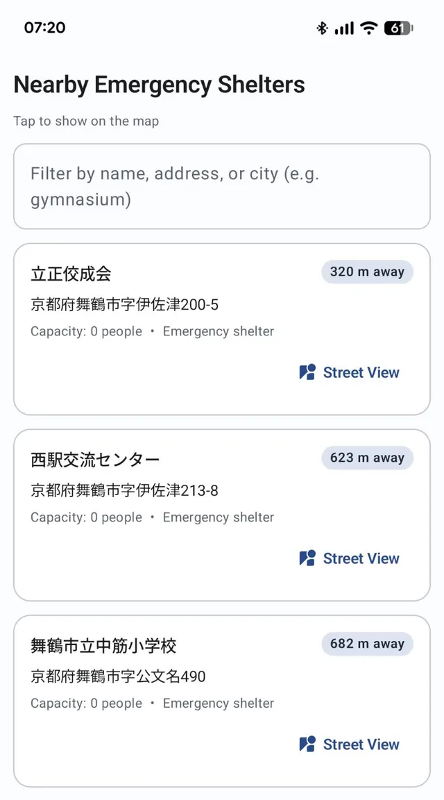
Find Nearby Emergency Shelters, Sorted by Distance
See designated emergency evacuation sites near your current location or any point you choose, listed from nearest to farthest. Filter the list by name, address, or city, and tap a shelter to jump to it on the map and see which direction it is.
Map: © OpenStreetMap contributors
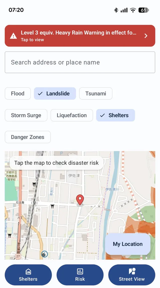
Color-Coded Hazard Layers on the Map
Overlay flood, landslide, tsunami, storm surge, liquefaction, and designated danger zone layers on the map in color. Switch layers on and off with one tap, and choose a spot by searching an address or place name, or just tapping the map.
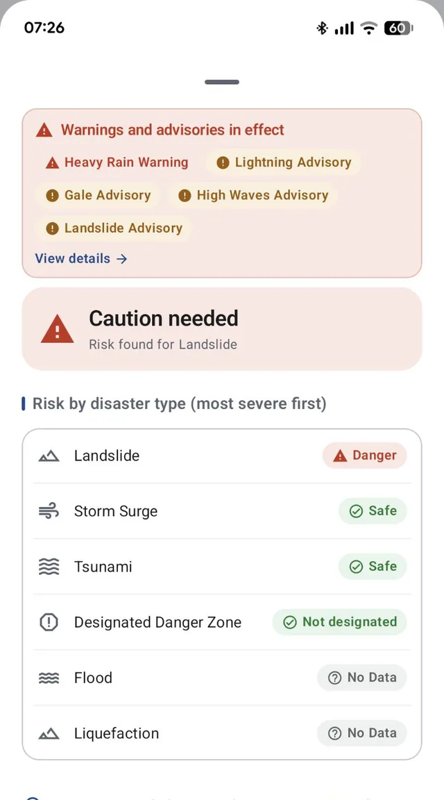
Tap Any Spot to See Its Risks, Most Severe First
Pick a location and get a list of its risks — landslide, tsunami, storm surge, designated danger zone, flood, and liquefaction — with the most severe at the top. An overall summary and any warnings in effect are shown alongside, so you get the key points at a glance. Where no data is available, the item is marked "No Data."
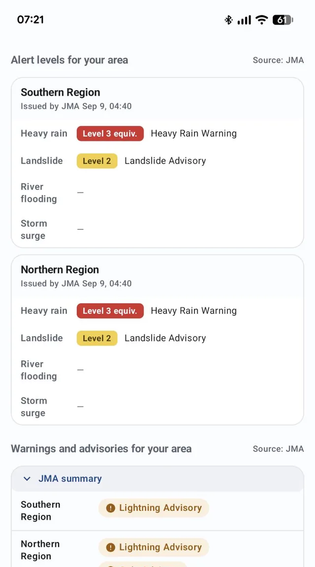
Alert Levels, Warnings, and Advisories from the Japan Meteorological Agency
See the alert levels (heavy rain, landslide, river flooding, storm surge) and the warnings and advisories issued for your area, exactly as published by the Japan Meteorological Agency (JMA). The app does not send push notifications, so open it to check the latest information.
Map: © OpenStreetMap contributors
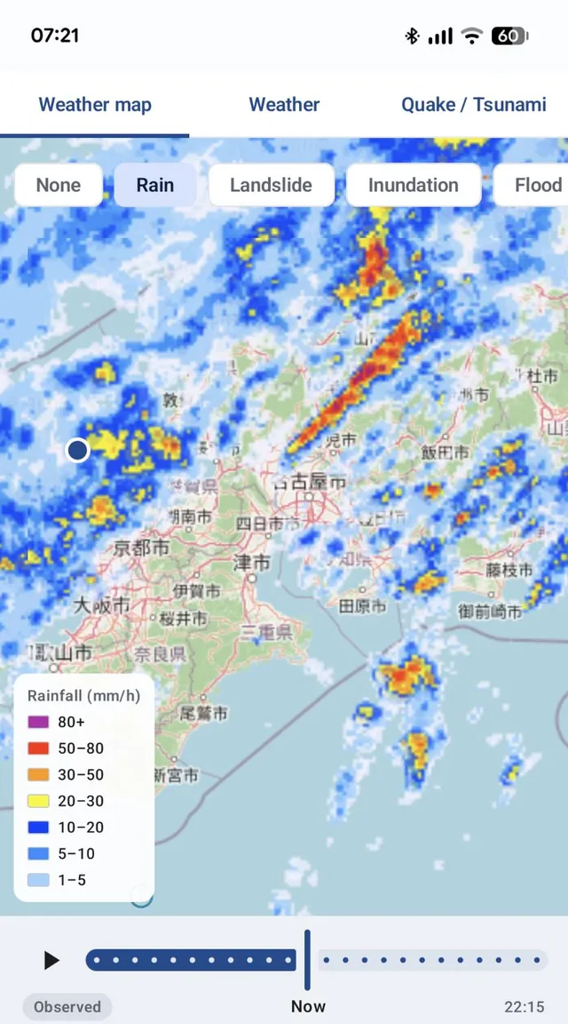
Weather Maps with a Timeline
Switch between rain, landslide, inundation, flood, and typhoon information on the map and play it back over time — useful for following heavy rain as it moves.
Also included:
- Weather forecasts (today, tomorrow, the day after, and the week ahead)
- Recent earthquakes (intensity and magnitude) and tsunami warning status
- Street View of the area around the selected spot (Google Street View)
How to Use
- Open the app to see the map.
- Search for an address or place name, or tap any spot on the map. (To check around your current location, allow location access — it's optional.)
- Check the list of risks for that spot.
- Toggle hazard layers such as flood and tsunami on the map.
- Open the list of nearby emergency shelters.
Frequently Asked Questions
Do I need to read Japanese?
The app interface is available in 12 languages, including English, and risk levels are shown with colors and icons. Shelter names, addresses, and map labels are shown in Japanese, as provided by the data sources.
Where does the data come from?
Hazard and shelter data come from the Real Estate Information Library of Japan's Ministry of Land, Infrastructure, Transport and Tourism (MLIT). Weather, alert, and earthquake information comes from the Japan Meteorological Agency (JMA). The base map is OpenStreetMap.
Is this an official government app?
No. It is an independently developed tool that displays public data; it is not operated or endorsed by MLIT or the JMA.
Is location access required?
No, it's optional. You can search for an address or place name, or tap the map instead.
Will it send me alerts?
No. The app does not send push notifications. Open the app to check the latest information.
Does it contain ads?
Yes. The app is free and shows ads.
Permissions & Privacy
- Location (optional): used to check risks around you and find nearby shelters. Without it, you can still search for an address or place name, or tap the map.
See the full Privacy Policy for details.
Specifications
| Supported OS | Android (Google Play checks compatibility with your device automatically on the install screen) |
|---|---|
| Languages | English, German, Spanish, French, Italian, Japanese, Korean, Dutch, Russian, Thai, Vietnamese, Chinese (Simplified) |
| Coverage | All of Japan (items without available data are shown as "No Data") |
| Price | Free (contains ads) |
Data Sources & Disclaimer
This app displays the following public data:
- Source: MLIT Real Estate Information Library (flood inundation zones, landslide hazard zones, tsunami inundation, storm surge inundation, liquefaction tendency, disaster danger zones, and designated emergency evacuation sites)
https://www.reinfolib.mlit.go.jp/ - Source: Japan Meteorological Agency (alert levels, warnings and advisories, weather forecasts, weather maps, earthquake and tsunami information)
https://www.jma.go.jp/jma/index.html - Base map: © OpenStreetMap contributors
This service uses the API of the Real Estate Information Library of Japan's Ministry of Land, Infrastructure, Transport and Tourism (MLIT), but the timeliness, accuracy, and completeness of the information provided are not guaranteed.
(原文)このサービスは、国土交通省の不動産情報ライブラリのAPI機能を使用していますが、提供情報の最新性、正確性、完全性等が保証されたものではありません。
Weather and earthquake information is shown exactly as issued by the Japan Meteorological Agency. This app sends no push notifications. Follow the instructions of your local government and the JMA when deciding whether to evacuate.
Hazard maps show projected scenarios; actual damage may differ. This app is an information tool — in an actual emergency, follow instructions from local authorities.
Try Japan Hazard Map & Shelter
The best time to find your shelter is before a disaster. Check the one near your hotel, home, or office today.
Get on Google Play 𝕏 Share